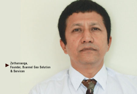
 Geographic Information System (GIS) is a technology which is not spoken about enough, but that does not take away from the fact that it holds the capability to have a rollicking change in the way we live and go about our lives. The West had adopted GIS relatively early compared to India which is still in the nascent stages of leveraging the technology. Keeping that aspect in mind, it was a brave move on the part of Zothansanga to incept Buannel Geo Solution & Services (BGSS) in Mizoram, far away from mainland India.
Established in 2008, the company is the first of a very few providing GIS solutions and services. Zothansanga, Founder, BGSS, says, “The primary motive behind starting BGSS was promotion of Geospatial technology for efficient management of all developmental works and which could further be used as a support system for other technologies.” Introducing a system that is designed to capture, store, manipulate, analyze, manage and present all types of spatial or geographical data was not phenomenal enough, the firm has made a mark at a national level, not to mention being the pioneers of GIS solutions & services in Mizoram which has put them in an enviable position where it has a head start to both the state’s Government and private sector projects.
Apart from being the first to set its foot in the GIS industry, the company to its credit has an array of services to offer - Remote Sensing & Photogrammetry (GIS map creation, Cadastral mapping, Contour mapping), and Surveillance (Hydrological survey, Control points survey) being the specialties. Being a professionally managed GIS firm, it provides sales and services of GIS related products for various departments viz.
Civil engineering (Land acquisition, Environmental impact protection, Geological mapping, Digital terrain mapping etc), Power & Energy (Satellite imagery for Topographical survey, Power transmission line mapping), Agriculture (Crop classification mapping, Crop condition assessment mapping), Urban planning (GIS base map creation, Digital terrain mapping, Geological & Geo technical study). The firm serves many more sectors such as Environment & Forestry, Water resources & Flood control, Telecom etc with equal vigor.
The eight year old organization had plenty of challenges to overcome before making a mark in the GIS industry, the most significant being the lack of awareness and funding. There were very few clients who dared to undertake the kind of services that the company provided. The priority for GIS afforded by the Government was quite low, as the substantiality of the technology on offer was as mentioned lost on them. But down the years GIS has gained popularity amongst the relevant authorities and clients.It provides optimum results with their services and ensures their presence from start to finish i.e. from procurement of GIS equipments to providing the end product.
The firm is backed by highly trained professionals, engineers and other specialists plus with efficient & flexible workflow, BGSS provides solutions and services as per client’s needs & requirements maintaining cost effectiveness and quality. The company has commanded numerous projects over the years with significant ones being GIS Mapping of Chhiahtlang Model Village , Mizoram , Landslide Zonation of Aizawl, GIS based Monitoring of Watershed Projects in three districts of Mizoram. BGSS aims to globalize its services and capitalize on upcoming government projects such as Digital India and Smart cities.

BGSS provides solutions and services as per client’s needs & requirements maintaining cost effectiveness and quality
The eight year old organization had plenty of challenges to overcome before making a mark in the GIS industry, the most significant being the lack of awareness and funding. There were very few clients who dared to undertake the kind of services that the company provided. The priority for GIS afforded by the Government was quite low, as the substantiality of the technology on offer was as mentioned lost on them. But down the years GIS has gained popularity amongst the relevant authorities and clients.It provides optimum results with their services and ensures their presence from start to finish i.e. from procurement of GIS equipments to providing the end product.
The firm is backed by highly trained professionals, engineers and other specialists plus with efficient & flexible workflow, BGSS provides solutions and services as per client’s needs & requirements maintaining cost effectiveness and quality. The company has commanded numerous projects over the years with significant ones being GIS Mapping of Chhiahtlang Model Village , Mizoram , Landslide Zonation of Aizawl, GIS based Monitoring of Watershed Projects in three districts of Mizoram. BGSS aims to globalize its services and capitalize on upcoming government projects such as Digital India and Smart cities.


.png)
